Since the first Google Maps mashup - maps overlaid with information - was created in 2005, a growing band of users have been making maps of hotels, pubs, restaurants, hotels, galleries, museums and anything else that can be plotted.
My website, Google Maps Mania, tracks the amazing mapping websites that are constantly being dreamed up. Here are 10 travel-related Google Maps mashups that I find invaluable whenever I go on holiday.
1. For real-time information: Wikitude
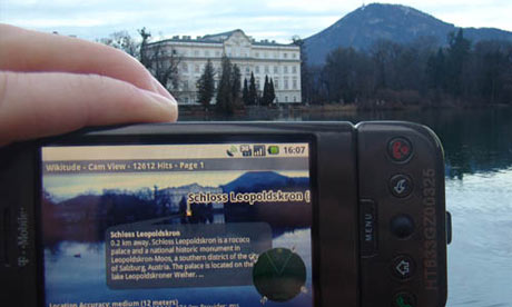
Wikitude is an application for Android mobile phones that includes a Google Map of 350,000 world-wide points of interest that can be displayed in a list view, map view or cam view. But the really astounding feature of Wikitude is the 'augmented reality' view that can be seen through your phone's screen. If you hold your phone in front of a mountain you can see the name and height of the mountain overlayed on top of it on your phone's screen. Walking around an unfamiliar city, users can view a building through their phone, and Wikitude then tags the building on the screen with relevant information about the building.
2. To see the sights before you visit: Google Maps Street View
The recent introduction of Street View to a number of countries around the world makes it possible to virtually explore holiday destinations before you leave. You can use Google Maps Street View on Google Maps in conjunction with the Wikipedia and Panoramio photo layers to find interesting sights to visit. In addition, some official tourist offices (and others) are beginning to introduce Street View options to their websites. For example ... Intoscana.it has produced a Street View map of Florence's major sights. I Amsterdam has just added some Street Views to its Explore the City map (so far the sights are a little uninspiring but the site plans to add more Street Views to the map). Street View Tourist is my own Street View map of a number of famous tourist destinations in the UK, Paris and Rome.
3. To plan ahead for a Gap Year: GoGapYear
The British Government's Foreign and Commonwealth Office have teamed up with Lonely Planet to produce this gap year planning tool built on top of Google Maps. The map includes photographs, podcasts and Lonely Planet reviews of tens of thousands of destinations around the world. You don't even need to be planning a gap year to benefit from this amazing map - it can tell you the best weeks to hike the Inca Trail, go diving in the Bahamas, or when you should visit Stromboli in Italy.
4. To map your own travels: Holiday Maps
Holiday Maps is a very cool website that lets you create your very own Google Map displaying all the places that you wish to visit on holiday. You can use the photo and Wikipedia layers to virtually explore your location in advance of your trip, and add markers to the map to show the location of galleries, museums and restaurants you plan to visit when you arrive. Once you have finished planning your trip you can print out your personal holiday map or, alternatively, you can just access it from your mobile phone when you arrive.
5. To find a hotel, and look inside: Tripr.tv
Tripr.tv lets you view video reviews of hotels so that you can actually see the hotel rooms and facilities on offer before you book. The videos are submitted by the site's users so the opinions voiced in them are independent. If you see a video of a hotel you like you can even book the hotel from the Tripr.tv site. Use the Google Map to zoom in on the area you would like to stay and then click on the map markers to view the video reviews.
6. To get tips from around the world: ZoomandGo
This impressive social network for tourists and travellers has a large collection of user-generated reviews, travel pictures and videos. ZoomAndGo provides Google Maps for individual locations around the world. Each map shows the top-rated hotels, galleries, museums and restaurants. The site aggregates each location's user rating for attractions, eating, shopping and scenery, so it is possible to quickly scan through towns and cities to see which have been rated the most highly by the site's users.
7. To find your nearest must-see sights: World Heritage Map
The World Heritage Map shows the location of the 878 properties that the World Heritage Committee have designated as having outstanding universal value. Check the map before setting out on your holiday to see which world treasures are within easy visiting distance of your chosen destination.
8. For frequent-traveller tips: Dopplr
Dopplr is very popular with frequent travellers as it lets members share their travel schedules. Recently, Dopplr released their City Pages feature which is a collection of information and tips for the top cities around the world. The tips are submitted by the site's members and include tips about the best places to stay and eat.
9. To search for anything, anywhere: Platial
Platial is a social networking website for travellers built on top of Google Maps which allows members to share their favourite places with the rest of the world. Travellers can access this submitted content via a simple search interface that asks the user what they are searching for and where. For example, you can search for restaurants in Paris, or museums in Barcelona. The results are then displayed on a Google Map, alongside user submitted reviews and photographs.
10. To find well-located budget accommodation: Hostelworld.com
For budget travellers Hostelworld.com is a great resource. The site has an online directory of hostels, budget accommodation centres and package tours. Hostels in the centre of cities are often the most expensive, but as Hostelworld.com allows you to search the directory via a Google Map, can easily visualise the balance between location and price.

