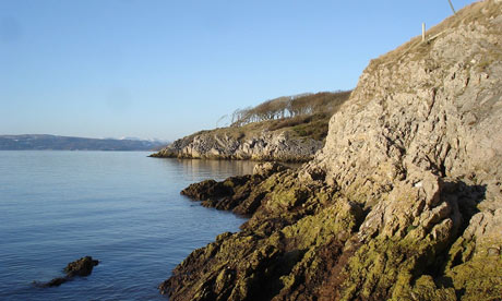
The views south to the Bowland fells and west across the shining expanse of Morecambe Bay shift and change as you progress round the point, making Silverdale a unique place for a walk. At this time of year at high tide, there are often large flocks of wading birds roosting at the edge of the saltmarsh near Jenny Brown's Point. At low tide, the winter light glints from the wet sand and the channels in the bay, forming amazing, ever-changing patterns.
Green woodpeckers can often be spotted on the first half of the walk, while the call of curlews provides an almost constant backdrop along the shoreline. The old copper-smelting chimney on the shore offers a unique reminder of the area's industrial past.
The view from the giant stone seat on Jack Scout is hard to beat. Try to be at Jack Scout as the sun goes down for a spectacular tapestry of gold reflections on the channels and sandbanks of the bay.
The village of Silverdale has three good pubs, each with its own character.
• Find out more at nationaltrust.org.uk/walks
Route and directions
Start: Woodwell car park. Grid ref: SD465754 Map: OS Landranger 97, Explorer OL7
1. Starting at Woodwell car park, listen out for the water cascade from the cliff base into a man-made pool - one of several original water supplies for the village. After looking into the pond and at the mysterious stone water features (were they for washing clothes or sheep?), turn to your right and follow the path alongside the field, then climb the steps to cross the road. Follow either of the two waymarked routes which bend to the left, and then climb over a stone stile. In the next field, turn left to follow a permissive route through a gate to the top of the hill.
2. You are now in a field with ancient anthills - an indication that it has not been ploughed for a long time. The ants build their nests to trap the warmth of the sun. Notice how most of the larger nests have a longer slope towards the sun on the south side - you now have a natural compass! Turn south to retrace your way to the footpath, turn left down the slope to the salt marsh, then turn right along the shore.
3. On the shoreline, look out for the old ore-smelting chimney (not National Trust). This area has a previously unknown industrial history, with many old quays now being revealed from under the eroding edge of the creek. From the chimney, take care over the rocks in front of the houses to reach the road. Continue onwards until you see a gate on the left where you will re-enter National Trust land.
4. You will now find yourself on the limestone grassland cliffs of Jack Scout. Look out for close-cropped turf: grazing by rabbits encourages the orchid "autumn lady's tresses" to flower in August and September. Patches of scrub support breeding songbirds here, while there are stunning sunset views to be had over Morecambe Bay – you may want to linger a little longer at this special place.
5. At the north end of Jack Scout is a lime kiln, where slaked lime was made from limestone for agricultural and building use. The display board explains how this was done. Behind the lime kiln is the gate back on to the road; turn left.
6. On your left at the end of the road is Lindeth Tower (not National Trust). In the 19th century, the tower was used by Elizabeth Gaskell, the Victorian author. Gaskell wrote the first biography of Charlotte Bronte, as well as a number of novels, some of which have recently been turned into television series. At the road junction turn left for about 200m, then turn right to return to the start point at Woodwell.
Terrain and accessibility
Allow about two hours for this one-and-three-quarter-mile (3km) circular walk. Walking conditions are easy, with some ascents and one steep descent and a total height gain of approximately 75m across the walk. It is advisable to wear walking boots. Point 3 is on the high-tide mark: beware of incoming tides and quicksands. Cliffs are dangerous – children should be supervised. Dogs under control are welcome.
Getting here and local facilities
By foot: The Lancashire Coastal Way passes through Arnside and Silverdale, along with many other footpaths
By bike: Near to Lancashire Cycleway on Regional Route 90. On-road cycling to and from the property sites on quiet country lanes. For more information visit sustrans.org.uk
By bus: Silverdale Circular 33 runs from Silverdale railway station to Silverdale Village and Holgates Caravan Site, Monday-Saturday. And bus number 550 runs from Kendal to Silverdale
By train: Silverdale and Arnside stations are both half a mile away
By road: Junction 35 M6, then A6 north, then west to Silverdale at Yealand Redmayne. Car park (not National Trust) at grid ref: SD465744. Toilets, shops and pubs in Silverdale.

