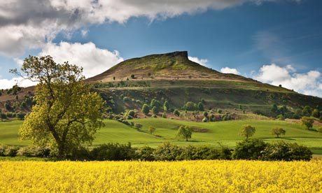
Roseberry Topping
Distance 2 miles
Start Newton-under-Roseberry, grid ref NZ570128
National Trust downloadable route and map
Though a relatively short walk, the ascent to Cleveland's most famous hill can be a challenge. It is a fascinating place to explore for its human and geological history, as well as its abundant wildlife. But it's the views from the top that will give you most reward for your efforts; the coastline, across the North York Moors and down onto industrial Teesside – a rich and varied landscape that's unveiled before you.
Roseberry Topping woodland wildlife
Distance 3 miles
Start Newton-under-Roseberry car park
National Trust downloadable route and map
While most visitors to Roseberry Topping head straight for the hill, there's plenty to see in the woods too. Newton Woods, just below it, is a wonderful place to walk and will take you to some of the best wildlife spotting opportunities. A haven for birds, look out for blue tits during April and May bringing caterpillars back for their chicks or listen out for the call of the green woodpecker; it's quite distinctive, sounding like hoarse laughter. And of course, in late spring Newton Woods is an amazing place to see carpets of bluebells as the ground is awash with colour.
Robin Hood's Bay to Boggle Hole
Distance 3 miles
Start Station car park, Robin Hood's Bay, grid ref NZ950054
Downloadable route and map
Take a walk along the Yorkshire coastline to Boggle Hole from Robin Hood's Bay – across the clifftops or the beach (at low tide only) and then return along the old railway back to your starting point. If the tide is low enough to walk the beach, take some time to look for fossils or in the rock pools.
Ravenscar loop
Distance 1½ miles
Start National Trust Coastal Centre, Ravenscar
National Trust downloadable route and map
Soak up the views as you discover Ravenscar, past and present, on this short walk. The little village boasts stunning views of the Yorkshire coastline across to Robin Hood's Bay. On this circular walk, you'll take in the old peak alum works but also have the option to find a wealth of flora and fauna – from bluebells in late spring to butterflies in summer. Keep an eye out for adders and damselflies too.
Kilburn Woods
Distance 3 miles
Start Sutton Bank National Park Centre (Grid Ref SE 516830)
Downloadable route and map
Take a walk from the top of Sutton Bank, with panoramic views across to Kilburn Woods. The woodland walk will take you along the old thieves' highway – once a quick getaway for highway robbers from the nearby drovers and stagecoach roads. You'll also walk past the white horse, which isn't as old as other landmarks across the country – it dates back to 1857.
Nettle Dale and the Hambleton Hills
Distance 9 miles
Start Sutton Bank National Park Centre, grid ref SE 516830
Downloadable route and map
Much of the North York Moors is farmland, with dry-stone walls, hedges and open moorland marking out the landscape. Look closely at the dry-stone walls and you may be able to spot fossil shells in amongst the stones. This walk will take you along footpaths and country lanes – in the summer, look out for wildflowers, buzzing bees and buttlerflies.
Rievaulx Terrace
Distance 1½ miles
Start Rievaulx Terrace car park, grid ref 100:SE579848
Click here for the Rievaulx Terrace website
Rievaulx Terrace is perfect for a gentle walk. These 18th-century landscape gardens were created for unwinding, relaxing and for spending time with others. In Ryedale, boasting views across the Hambleton Hills and down to Rievaulx Abbey, a walk along the Terrace will give you unrivalled views of the surrounding countryside and, if you're lucky, a glimpse of the wildlife that makes this Georgian landscape its home.
Nunnington to Rievaulx
Distance 8 miles (2½ hours). Take the circular route, for a 16-mile, five-hour walk
Start Nunnington Hall, YO62 5UY
Further information on walks in the area
In the heart of Ryedale, not far from Helmsley, is the village of Nunnington. The hall, owned by the National Trust is just one reason to find your way to this part of Yorkshire, but be sure to explore the village and surrounding area a little wider too. Rievaulx Terrace is just eight miles away and itself boasts unrivalled views of the Hambleton Hills and Rievaulx Abbey.
Hutton-le-Hole to Lingmoor
Distance 3.6 miles
Start Hutton-le-Hole car park, grid ref SE 705903
Downloadable route and map
Hutton-le-Hole sits within the North York Moors national park and, according to their walking guide, in Victorian England it was described as "an ill-planned and untidy" village. Thankfully, times and opinions have changed and it now recognised as one of Britain's most beautiful and picturesque. A circular walk towards Spaunton will help you escape into the national park and across fields and country tracks.
Coast to Coast
Start St Bee's, Cumbria
Finish Robin Hood's Bay
Total distance 190 miles
Walk website
If you're looking for more of a walking challenge, then there are many national routes that travel across North Yorkshire, including the Pennine Way. The Coast to Coast trail takes you right across the country, covering 190 miles, from St Bee's in Cumbria in the west to Robin Hood's Bay in the east, taking three national parks – the Lake District, Yorkshire Dales and North York Moors. You can choose to do the whole route over 14 days or select sections for shorter day-long walks.
Know any great walks in the area? Add your recommendation in the comments below

