England
Beacon Hill, The Chilterns, Buckinghamshire
Slap-bang in the middle of the northern ridge of the Chilterns, a small section folds inwards to create an amphitheatre of forested chalk foothills, peppered with smaller domed knolls and leafy hollows. From this wooded basin, a sharp spur rises 259m (850ft), revealing an exhilarating view across the lower-lying vale to Quainton Hill with glimpses of Oxfordshire and Northamptonshire beyond. The spur is known as Beacon Hill and it is just one of many impressive viewpoints along the Chilterns' escarpment. We've plumped for this lesser-known vantage point mostly because it provides a route that lazily avoids many of the steeper climbs in the area. This is a short, leisurely walk on reddish-brown soil and black flint tracks that plunges you into fresh woodland, then disgorges you among flower-rich meadows. You'll have plenty of time to study the glorious red kites, spread out a picnic hamper in the pleasant leas of Grangelands Nature Reserve or simply sit for a while on the soft knoll of Chequers' Knap, watching the sun go down.
Eat The Plough (01844 343302; ploughatcadsden.com) in the hamlet of Cadsden has good food and well-maintained ales and walkers and families are particularly welcome
Stay The Red Lion (01844 344476; theredlionwhiteleaf.co.uk) at nearby Whiteleaf is a family-run, 17th-century inn offering excellent food and comfortable accommodation
Map OS Explorer 181
Start/finish Circular from Little Kimble train station (map reference SP823066)
Length 5 miles, one short but steep climb
The Norber Erratics, Yorkshire
This relatively short route takes you through one of the most striking of the newly opened areas in the Yorkshire Dales National Park, above the pretty beckside village of Clapham. From the limestone crags spread over the hilltop of Thwaite Scars you gain a cracking view of a dale that deserves to be much better known. Enclosed on three sides by pale-grey escarpments, the walled fields and green lanes of Crummackdale are ringed by an almost lunar landscape, scoured by a glacier 15,000 years ago. The same ice flow was also responsible for one of the great geological oddities of the park; the Norber Erratics, a collection of sandstone boulders daintily perched on little limestone legs at the mouth of Crummackdale. The Norbers provide a memorable finale to a walk through a landscape dramatically shaped by the action of water and ice on stone. Here you get to see some of the defining features of this terrain including a meltwater ravine, limestone pavements, one of the dales' most famous showcaves and, of course, the extraordinary Norber Erratics - without venturing more than an hour from the nearest tearooms.
Eat The New Inn (01524 251203) in Clapham offers traditional hearty Yorkshire fare of mostly beef, lamb or pork
Stay Brook House (01524 251580; brookhouse-clapham.co.uk) is a tasteful and reasonably priced B&B next to Clapham Beck
Map OS Explorer 0L2
Start/finish Circular from the New Inn pub at Clapham (SD745691)
Length 6 miles
The Stiperstones, Shropshire
The Stiperstones in south Shropshire extend across classic border terrain - an area of overlap and ambiguity, where accents merge, landscapes shift and stories of supernatural and heroic deeds abound. Erupting at regular intervals from its mantle of purple heather and lime green whinberry bushes are outcrops of wild, jagged tors, interlaced by ancient tracks. Although they rise to only 536m (1,758ft), these lonely outcrops afford some of the finest views in central England. In clear weather you can see from the Malverns to the Peak District but when mist enfolds the ridge the stones take on a more sinister mood, inducing a sense of claustrophobia. Legend asserts that witches congregate around them and that the Devil keeps a seat here. His eponymous Chair is one of four prominent quartzite outcrops skirted by this route in the course of its north-south traverse of the ridge. It approaches the Stiperstones from the gentler east flank of the hill, via a trail across verdant sheep country. Fine panoramas extend back to the Long Mynd and Church Stretton area as you climb.
Eat The Horseshoe Inn (01588 650260; horseshoeinnbridges.co.uk) in Bridges, south of Shrewsbury, offers delicious homemade meals in an oak-lined interior
Stay The Horseshoe Inn has rooms with exposed beams and modern facilities that are perfectly placed for the route
Map OS Explorer 216/217
Start/finish Circular from the Horseshoe Inn at Bridges (SO393965)
Length 7.5 miles
British Camp, The Malverns, Herefordshire
Some hilltop views inspire rapture, others a sense of doom. Some just evoke a mood of quiet, affirmatory contemplation - a feeling that all is right in the world. The Malverns, on the Herefordshire-Worcestershire border, fall into the latter category. The classic walking route is the traverse between the two highest summits: Worcestershire Beacon (425m, 1,394ft) in the north and Herefordshire Beacon, aka "British Camp" (338m, 1,109ft) in the south. Lined for most of its length with an iron-age earthwork, the ridge path crosses five named peaks, where outcrops of pre-Cambrian gneiss - a volcanic rock otherwise found only in the far north-west of Scotland - fall away to steep, grassy slopes carpeted in bracken and gorse. Once you're clear of the tree level, spellbinding views accompany the entire walk. Thanks to the walker-friendly Hopper Bus that loops around the hills on summer weekends, you can make it a linear trip, staying high all day.
Eat The Nags Head (01684 574373) in Malvern is an eccentric old pub serving the town's best real ales and popular bar meals
Stay Old Country Farm (01886 880867; oldcountryhouse.co.uk) is a quality B&B in a beautiful 600-year-old house
Map OS Explorer 190
Start/finish Great Malvern priory (SO776458) to the Herefordshire beacon (SO762403)
Length 7.5 miles, initially steep ascent
Bedruthan, Cornwall
Jutting its jaw defiantly into the Atlantic, north Cornwall faces the full might of the ocean, and for much of the year the gales howl in with umbrella-defying ferocity, blowing mountainous waves against the slate cliffs and twisting any exposed blackthorn trees into improbable angles. This is an austere landscape, synonymous with shipwrecks and smugglers. The route includes a Cornish classic: the clifftop vista over Bedruthan Steps, where a rank of colossal, pointed stacks march out of the breakers against a dramatic backdrop of slate escarpments. Meandering past a succession of picture-postcard coves, windswept headlands and old-fashioned holiday resorts, this stretch of the coast path running north of Bedruthan ranks among the prettiest in the south west.
Eat The Falcon (01637 860225) is indisputably the nicest pub in the area, though you'll have to plod up the valley from Mawgan Porth for half an hour to reach it
Stay Few youth hostels occupy as splendid a site as Treyarnon Youth Hostel (0845 371 9664; yha.org.uk)
Map OS Explorer 106
Start/finish Mawgan Porth (SW850672) to Harlyn Bridge (SW878753)
Length 10.5 miles, but can be cut to 7
Mam Tor, Peak District, Derbyshire
The Peak District is a classic British misnomer; although it holds more than its fair share of cliffs, gorges and high moorland, proper pointy peaks with 360° panoramas are in short supply. One corner of the park, however, provides the exception. Enfolded by an arc of prominent summits, the head of the Hope Valley around Castleton can claim a near monopoly on the Peak's peaks. Moreover, the tops are strung together by a single classic ridge. Stretching for two miles from east to west, the Great Ridge straddles the geographical faultline where the rolling pastures of the White Peak collide with the millstone grit and peaty wasters of the dour Dark Peak to the north. To put the Great Ridge in context, The route combines the walk along it between Lose Hill and Mam Tor with a gentle foray into the limestone country on the southern side of the valley. Crossing a checkerboard of sheep folds and disused lead mines, it then drops back to Castleton via picturesque Cave Dale, whose narrow sides steep and converge as they approach the fairytale vision of Peveril Castle - one of the Peak's great manmade spectacles.
Eat The Cheshire Cheese (01433 620381) is a snug oak-beamed pub in Hope that's as old as the hills and serves copious meals
Stay Underleigh House (01433 621372; underleighhouse.co.uk) is an award-winning B&B in Hope
Map OS Explorer OL1
Start/finish Circular from the Castleton Visitor Information Centre (SK149830)
Length 8 miles with a steep initial ascent
Golden Cap, Charmouth, Dorset
The views from the little plateau at the summit of Golden Cap are sensational, extending from Start Point in south Devon across the spectacular sweep of Chesil beach to Portland Bill in the east and inland across a landscape of low hills and pretty thatched villages. Ascents of Golden Cap tend to come in two forms: short and sharp (straight up the east flank from Seatown) or short and soft (from the Langdon Hill car park halfway up its northern side). The best route adopts a more convoluted approach, admiring views of the hill before savouring the views from it. The terrain - ancient green lanes, hidden sea combes, bracken-covered commons, windy clifftops - is as varied as any on the British coastline. We suggest a figure-of-eight route, starting and ending at the Anchor Inn at Seatown. It can be divided into two stages - if you're short of time, limit yourself to the second loop over Golden Cap, with perhaps a side trip up Doghouse Hill and Thorncombe Beacon to the east.
Eat The Anchor Inn (01297 489215) has a perfect location at the foot of Golden Cap, in Seatown. A little worn around the edges, but genuinely hospitable
Stay Seahill House (01297 489801; seahill.co.uk) is a smartly-furnished, self-catering cottage on the lower slopes of Golden Cap
Map OS Explorer 116
Start/finish Circular from the Anchor Inn, Seatown (SY420918)
Length 8.5 miles but can be cut in two
Fleetwith Pike, Keswick, Lake District
At less than two miles long, Buttermere is far from the largest lake in the region, but it couldn't have been more perfectly formed to complement the high fells surrounding it. There is, however, one perspective on Buttermere that's in a class of its own. Overlooking the south-west end of the lake is what looks like, when seen from the water's edge, a rather squat pyramid fell. In late summer, where the heather's in bloom and the enfolding summits trail shreds of mist, Fleetwith Pike has a truly commanding presence about it. Apart from the position right in the centre of one of Lakeland's most scenic enclaves, the main reason Fleetwith qualifies as a great viewpoint is the abruptness with which its north-west ridge - known ominously as The Edge - rises from the waterside. It's this airy, broken line which the route follows to the top. After barely 10 minutes of strenuous climbing, a superb vista unfolds of wavering ridges, cliffs, corries and summits, centred on a string of lakes that draw your eye down the valley to the blue line of the seas, with the distant mountains of Dumfries and Galloway fringing the horizon.
Eat The Fish Hotel (01768 770253; fish-hotel.co.uk) in Buttermere village serves quality bar food
Stay Dalegarth Guest House (01768 770233; dalegarthguesthouse.co.uk) is less than a mile from the start of the route and offers good-value accommodation
Map OS Explorer OL4
Start/finish Circular from the Gatesgarth farm car park (NY195150)
Length 5.5 miles along rough and rocky mountain paths
Coaley Peak, Cotswolds
Think of the Cotswolds and you probably imagine honey-coloured thatched cottages and immaculate village greens. Think again. The Cotswolds start sedately enough in the south and east but come to an uncharacteristically dramatic conclusion in the west and north, shelving nearly 1,000m (984ft) in about as far as your average dog-walker can flick a Frisbee. Twisting and turning as it progresses north, this mighty escarpment is what geologists call a "classic cuesta" but to local people it's "the Edge".
For impact, few vistas along the Edge can beat the one from Selsley Common, southwest of Stroud: a topograph next to the tumulus picks out features as far away as the Sugar Loaf and Hay Bluff. Beginning at Coaley Peak viewpoint on the B4066, the route approaches Selsley Common via the Cotswold Edge, then swings south into the landscaped valley of Woodchester Park, bringing together two contrasting facets of the Cotswolds in one exceptionally satisfying walk.
Eat The Bell Inn (01453 764910) in Selsley, is a typical Cotswold pub and a good place to break for real ale and home-cooked meals
Stay The Rose & Crown (01453 860240) offers good value B&B above a coaching inn that claims to be the highest in the Cotswolds
Map OS Outdoor Leisure 168
Start/finish Circular from the Coaley Peak viewpoint car park (SO794013)
Length 8.7 miles, mostly easy walking with a few short steep ascents
Cley-Next-The-Sea, Norfolk
The Peddars Way and Norfolk Coast Path winds through a network of nature reserves littered with abandoned fishing boats and crisscrossed with boardwalks and birdwatching hides. On the approach to Cley-next-the-Sea, the broad landscape and open skies are neatly punctuated by the silhouette of the 18th-century windmill, one of Norfolk's defining landmarks.
The second half of this route retreats inland through the fens of the Glaven Valley, before climbing onto Blakeney Esker for panoramic views of north Norfolk. The churches at Blakeney, Wiveton and Cley decorate this tapestry of golden marshland stretching north to the shingle spit of Blakeney Point, and from the ridge of the esker you finally glimpse the elusive North Sea, on the final leg of your journey back to Blakeney harbour.
Eat Picnic Fayre and the Cley Smokehouse in Cley-next-the-Sea are perfectly positioned to stock up for the second leg of the route. For a more substantial meal, the Three Swallows (01263 740526), off the old village green, has open fires and pub games
Stay Cley Windmill (01263 740209; cleywindmill.co.uk), Holt, has upmarket B&B and self-catering accommodation with sweeping views of the marshes
Map OS Explorer 251
Start/finish Circular from the Blakeney Quay, Blakeney (TG027441)
Length 9.7 miles, can be muddy but mostly lanes and bridleways with good surfaces
Clifton Suspension Bridge, Bristol
No other city in England enjoys as spectacular a situation as Bristol, the West Country's carbuncle-ridden but undeniably charismatic capital. Piled up the flanks of a steep-sided hill, it rises from the banks of the Avon in a quintessentially English jumble of cobbled quaysides, half-timbered pubs, church spires, concrete car parks and glass-sided office blocks.
The route starts with the magnificent panorama over the Avon Gorge and Brunel's suspension bridge from the Clifton Observatory. From there, it loops through the Leigh Woods nature reserve on the opposite side of the bridge, before plunging down a forested valley to the river bank and a compelling walk along the harbourside.
In the first couple of hours you get to clamber over iron-age ramparts, spot some of the world's rarest plants, admire the graceful lines of the SS Great Britain and enjoy Bristol's skyline over a pint of Somerset scrumpy. Throw in a couple of side trips - to see the cathedral's exquisite Norman chapterhouse, or the Elizabethan Red House on Park Row - and you have a memorable day's walking.
Eat The Albion, Boyce's Avenue, Clifton (0117 973 3522; thealbionclifton.co.uk) is Bristol's poshest gastro-pub and occupies a handsome Georgian building
Stay Bristol International Youth Hostel (Narrow Quay; 0870 770 5726; yha.org.uk) is bang on the waterfront . Alternatively try Park House (0117 973 6331), a delightful B&B in one of Clifton's oldest Georgian residences
Maps Geographer's A-Z: Bristol (132507); OS Explorer 155
Start/finish Circular from Clifton Suspension Bridge (ST565733)
Length 7.8 miles. Don't think because it's near the city it's easy - Bristol is full of calf-busting gradients
The Roaches, Staffordshire
"Great crooked crags, cruelly jagged, the bristling barbs of rock seemed to brush the sky," was how the nameless author of Sir Gawain and the Green Knight described Staffordshire's Roaches. Seven hundred years on, the mighty gritstone cliffs, whose knotted, lumpen faces loom above the main Leek to Buxton road, strike a no less imposing profile.
The ridge holds four distinct summits, the most prominent of them Hen Cloud, the Midlands' answer to the Rock of Gibraltar. Start by following in the footsteps of Sir Gawain: along the ridge's high tier and down the far side through a tract of twisted oaks and beech trees straight from the pages of a medieval romance. Hidden in the depths of this fairytale forest is Lud's Church, a kind of miniature gorge draped with mosses and ferns, which scholars have identified as the inspiration for Sir Gawain's Green Chapel. From there, loop back up to the ridge and retrace your steps to the foot of Hen Cloud - the final climb of the day.
Eat The Roaches Tea Rooms (01538 300345; roachestearooms.co.uk) in Upper Hulme serves breakfast, lunch and light bites. The best pub is the Wilkes Head seven miles away in Leek
Stay The Roaches Tea Rooms (as before) offers self-catering cottages, or the YHA Gradbach (0845 3719118; yha.org.uk) is in a secluded vale on the Lud's Church side of the escarpment
Map OS Explorer OL24
Start/finish Circular from Roaches Gate car park (SK004622)
Length 8.5 miles, fairly easy gradients
Embleton Bay, Northumberland
The ruins of Dunstanburgh Castle cast a melancholic spell over one of the emptiest, most beautiful stretches of the Northumberland coast, just south of the Farne Islands.
Starting at the fishing harbour of Craster, where you can steel yourself for the walk ahead with a plate of locally smoked kipper, the route winds across Embleton Bay to reach Low Newton-by-the-Sea, a tiny cluster of stone fishermen's houses. The pocket-sized Ship Inn has to be one of Britain's most delightful watering holes, cowering out of the wind next to the green. The perfect turning point for the route, it serves its own home-brewed beer, and fresh lobsters caught by the landlady's son-in-law. This is a walk that should ideally be saved for a bright, windy day, when the sea colours are at their most vivid. Bring a kite and pair of field glasses to spot the seabirds that congregate here in impressive numbers. If you're lucky you might even catch a glimpse of a basking seal.
Eat The Ship Inn (01665 576262; shipinnnewton.co.uk) is pub perfection. Craster Fish Restaurant (01665 576223) is the place for the definitive Craster kipper experience
Stay Cottage Inn, Dunstan (01665 576658; cottageinnhotel.co.uk) is a large, upscale - but reasonably priced - B&B option set in woodland on the edge of Craster
Maps OS Explorer 332 and 340
Start/finish Circular from Craster Tourist Information Centre (NU256198)
Length 7.5miles. Gentle coastal paths crossing low cliffs, sandy beaches and dunes. Some muddy stretches
High Cup Nick, Cumbria
At the northwestern flank of the Pennines, the high fells tumble abruptly into the lush checkerboard of the Eden Valley. A phalanx of low, conical hills, known locally as "pikes", stand proud of this mighty scarp edge, gazing across the vale to the peaks of the Lake District.
Writing from exile in New York during the second world war, a homesick WH Auden described this forgotten corner of northern England as "one of the sacred places of the earth". And if your first glimpse of it is through the mists swirling around the head of High Cup Gill, you'll understand why. A great chasm of dolerite gouged from the fellside above Appleby-in-Westmorland, High Cup Gill forms the western extremity of the Great Whin Sill layer of igneous rock running northeast from here to the Farne Islands. Viewed from the stream trickling over its head - a vantage point known as "High Cup Nick" - the valley's smooth, grassy, scree-streaked walls sweep to a fringe of blue-grey crags. The walk follows the Pennine Way uphill from Dufton to the famous viewpoint. From there, it runs around the opposite, eastern rim of the valley, descending a moorland spur to regain road level, from where an amble over pasture land takes you back to the Pennine Way above Dufton.
Eat The location of the Stag Inn (01768 351608; thestagdufton.co.uk) - on the village green in Dufton - couldn't be more perfect. Get there early for a table
Stay Brow Farm, Dufton (01768 352865; browfarm.com) is a comfortable, inexpensive B&B in a converted mid-18th-century barn of local red sandstone, five minutes from the pub in Dufton
Map OS Explorer OL19
Start/finish Circular from Dufton village green (NY689251)
Length 10 miles. Some of the moorland paths are uneven and boggy
The Seven Sisters, East Sussex
It's as if the sea formed the Seven Sisters expressly to test the skill of sailors. From the base of these sheer chalk cliffs on the Sussex Downs, a shelf of submerged rock slices into the English Channel, posing a lethal hazard for passing ships. As many as 87 have been lost along this isolated stretch of coast since the 17th century, earning it the nickname "the mariners' graveyard".
These coastal hills provide some of the most remarkable coast walking in Britain. It's hard not to feel exhilarated as you climb aboard the Seven Sisters "rollercoaster". To one side, the lush green turf of the clifftops, speckled with hoary stock and clumps of pink thrift. To the other, the massive ramparts of chalk swooping in graceful curves to Beachy Head and the distant Belle Tout lighthouse. The walk takes you on an undulating ride from Went Hill Brow on to Baily's Brow, Flagstaff Point, Brass Point, Rough Brow, Short Brow and Haven Brow. A short meander around the beautiful estuary of Cuckmere Haven and a final climb past the old coastguards' cottages up to Seaford Head completes the trip.
Eat The Tiger Inn, The Green, East Dean (01323 423209) is an idyllic country pub, serving Harvey's Best and Horsham ale
Stay The Boathouse, Birling Gap. Just up the track away from the hubbub of the multi-purpose Birling Gap Hotel, the Boathouse (01323 423073) is a quieter alternative
Map OS Explorer 123
Start/finish East Dean, Tiger Inn (TV557978) to Seaford, Martello Tower (TV485985)
Length 8 miles. Easy walking but stay back from the cliff edges
Scotland
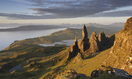
The Old Man of Storr, Skye, Inner Hebrides
The longest inland cliff in Britain, the Trotternish Ridge zigzags for 23 miles between Portree to the northern tip of Skye, where it tumbles into a belt of springy turf speckled with tiny white crofts. Because it stares across the Sound of Raasay to the Scottish mainland, the mighty east cliff of the Trotternish Ridge yields a breathtaking panoramic view over the mountain ranges of the Highlands, stretching from Assynt in the far northwest to Ben Nevis in central Scotland. What's more, you don't have to climb all the way up to the scarp edge to get what is generally regarded as the best view from the Trotternish Ridge.
With the Old Man of Storr, one of Britain's most perfect views finds its perfect foreground - a towering needle of petrified lava. The monolith rises from a knot of lesser pinnacles clustered around its base like eroded Easter Island giants, tilted slightly seawards as if hypnotised by the spectacle. The best viewpoint, from a bluff overlooking the Old Man, lies only an hour from the road.
Eat Harbour View (01478 612069; harbourviewskye.co.uk) seafood restaurant is the place to sample Loch Harport oysters
Stay Coolin View Guest House (01478 611280; coolinview.co.uk), a clean, well-run and comfortable base
Map OS Explorer 408
Start/finish Up and back from a lay-by on the A855 (NG509 529)
Length 2.5 miles, mostly uphill
Glen Finnan, The Highlands
This is almost sacred ground for Scots. It was at Glenfinnan in August 1745 that Bonnie Prince Charlie unfurled his standard to signal the start of the ill-fated uprising. The route makes a pilgrimage to the supposed site of the flag-raising, just above the modern visitor centre on the main Fort William to Mallaig road. Even without its historic associations, this viewpoint would rank among the finest in Scotland, offering a superb panorama over Loch Shiel and across to the mountains of the Corryhully Horseshoe beyond.
From the opposite side of the river, an estate road delves northwards into the beautiful valley of Glen Finnan. It was along this route that the Clan Cameron descended in 1745 to tip the scales of the Jacobite cause in favour of action. Follow their tracks in reverse, along the banks of the Finnan to the Corryhully Bothy, a pretty stone walkers' hut. From there, a higher track leads through a spruce forest down the south side of the valley back to the viaduct and visitor centre.
Eat The Station Dining Car Glenfinnan Railway Station (01397 722300) is a lovingly converted 1950s Pullman carriage
Stay The Glenfinnan Sleeping Car, a railway carriage at the same station (01397 722295; road-to-the-isles.org.uk). For something more conventional, try the Glenfinnan House Hotel (01397 722235; glenfinnanhouse.com), a smart country hotel
Map OS Explorer 398
Start/finish Circular from Glenfinnan Visitor Centre (NM908807)
Length 6.5 miles, mostly easy walking
Salisbury Crags, Edinburgh
No list of great British walks could possibly omit Arthur's Seat, the dramatic dollop of Scottish wilderness rising unexpectedly from the heart of Edinburgh. The plug of an extinct volcano, the hill and its outlying ramparts soar 251m (823ft) above the medieval roofscape of the Royal Mile. On a clear day, you can survey not just the entire Scottish capital, but also its majestic context. To the north: the Firth of the Forth, the Ochils and Trossachs; to the south, the Pentland Hills rolling away towards the English border.
Beginning at the Scottish Parliament Building, the walk hugs Salisbury Crags, gaining the summit of the hill by means of the fantastic zigzagging path up "Guttit Haddie" - an ascent which will make you feel you've earned the superb panorama from the top.
Eat Henderson's (94 Hanover St, 0131 225 2131) is an Edinburgh institution, serving great organic veggie food in a bistro-style setting
Stay Edinburgh's awash with backpacker hostels, but the Smart City Hostel in the Old Town (0131 524 1989; smartcityhostels.com) as its name suggests, is smarter - and larger - than most, and they offer individual rooms as well as dorm beds
Maps OS Explorer 350; Insight Fleximap: Edinburgh
Start/finish Circular from Scottish Parliament Building (NT268738)
Length Three miles, steep in places, summit rocks can be very slippery
Wales
Capel-Y-Ffin, Monmouthshire
"One of the emotional centres of my life," is how Bruce Chatwin described the Vale of Ewyas, a remote Shangri-la buried deep in the Black Mountains, the easternmost massif of the Brecon Beacons National Park. That this is the prettiest of all Welsh valleys few would deny. To fully appreciate why, you have to follow one of the old pony trails zigzagging up its flanks through the ferns to the round-topped, heather-covered moorland plateaux beyond. Looking down the Vale, the exquisite symmetry of its glaciated sides is fully revealed, along with the drama of the valley's setting. When clouds swirl about their ridges, and great beams of sunlight sweep across the fields, the Black Mountains embracing Ewyas certainly live up to their name. Following old drovers' tracks, the route climbs from the sheltered floor of the valley at Capel-y-ffin to the windswept, bleak hilltop marking the English border to the east. Having reached Offa's Dyke Path, you've a choice between carrying on via the ridge, or a more strenuous foray down into the Olchon Valley - another forgotten mountain cul de sac.
Eat The Half Moon Inn (01873 890611; halfmoon-llanthony.co.uk) in Llanthony serves meals that are copious and good value
Stay Castle Farm (07973 837820; capel-y-ffin.co.uk) has a pretty self-catering cottage and adjacent five-bedroom farmhouse
Map OS Explorer OL13
Start/finish Circular from Capel-y-Ffin (SO265314)
Length 10 miles with sustained ascents and descents
Yr Eifl, Gwynedd
The Eifl hills offer three irresistible reasons to travel to the Lleyn peninsula in North Wales: the way they rise so abruptly from the peninsula's rocky north coast, against an epic backdrop of churning Atlantic surf and wild mountains; the presence on the easternmost peak, Tre'r Ceiri, of a magnificent hill-fort, known locally as the "Town of Giants"; and the stupendous views from the top of the highest hill, Garn Ganol. Thanks to its seaside location, this miniature Mount Fuji yields a grandstand view inland to the giants of the Snowdonia range, and south across Cardigan Bay to the Rhinogs, Preselis and distant carns of St David's Head. The real wonder, visible only on the clearest of days, is the silhouette, on a strip of horizon beyond Anglesey, of Helvellyn - 120 miles away.
Eat The Ty Coch Inn in Porth Dinllaen, Nefyn (01758 720498; tycoch.co.uk) is surely one of the best situated pubs in Britain. It's only accessible on foot, along the beach
Stay Tir Bach Campsite Pistyll, 2.2miles southwest of Llithfaen (01758 720074) is a well-kept site with just a couple of small, sloping fields on the cliffs next to the road. Alternatively, head for the Nanhoron Hotel, Nefyn (01758 720203; nanhoronhotel.com)
Map OS Explorer 254
Start/finish Llithfaen village (SH 356432)
Length 3.7 miles, clear trails on open moorland, with short, steep ascents and descents
• Extracted from "Walk Britain's Great Views", published by The Ramblers on 1 May, available at the Guardian bookshop for £14.99, or free to Ramblers members. For stockists' details and inquiries about joining the organistion contact 020 7339 8500, or see ramblers.org.uk
