Route information
Length 18 miles
Duration 2-3 hours
Start/Finish Fairholmes Visitor Centre
Classification Moderate
Terrain Road/off-road, hills
Who's it good for? Families with older kids, a day out with friends, if you're new to cycling
Map OS OL1 (Peak District – Dark Peak Area) or Landranger 110 (Sheffield & Huddersfield)
Pedalling the peaks
If you've ever thought the Peak District's title doesn't quite hit the spot – Crag District, perhaps? Dale District? – you'd have a point. The name, you see, derives from the Old English "peac", meaning hill; nobody could quibble with that. And while that pulls in hikers, who revel in exploring its ridges, tors, scouts and edges, the moniker could be offputting for families and casual cyclists.
Which would be a shame, given the wealth of trails suitable for a relaxing day's cycling. Thanks, in part, to the efforts of the Peak District National Park Authority, 65 miles of traffic-free routes traverse the region, not to mention 280 miles of cycle routes across Derbyshire, more than 200 on greenways.
Maybe "Reservoir District" would be more apt? After all, a reservoir is really just a river after a bit of nip and tuck – and the two-dozen or so dotting the Dark Peak between Manchester and Sheffield are beauties.
Take in the waters
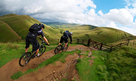
The Three Reservoirs trail in the Upper Derwent Valley is a perfect marriage of bikes and barrages. An 18-mile loop of quiet roads and well-kept tracks, it's challenging enough to fill a hearty day's pedalling, but accessible to most hobbyists, with short cuts and a cafe for when the blood-sugar levels dip.
Not to say it's tame. High, heather-purpled moors loom to the north, steep-sided valleys and cloughs notch the reservoir's fringes and woodland cloaks the hillsides. Indeed, this High Peak landscape resembles the Scottish Highlands more than the craggy, field-checked White Peak to the south.
Underwater hamlets
The titular three reservoirs – Ladybower, Derwent and Howden – were dammed early last century, somewhat controversially, and two hamlets were largely submerged, although the ghostly belltower of Derwent's church may be visible in arid summers.
Best known for providing training runs for the "Dambusters", equipped with Barnes Wallis's bouncing bombs, these dams look more like medieval castellations than mere water-retainers.
The logical starting point is Fairholmes car park, with its visitor centre offering cycle hire, refreshments, toilets and picnic sites. The trail begins on a tarmac road – closed to motorised traffic on summer weekends – skirting the west shore of Derwent Reservoir and passing Howden Dam before tapering to a limestone track. Climbing through forest, it then forks right and drops to the old packhorse bridge, relocated from poor drowned Derwent.
The track south, lumpy and steep in patches, climbs above the eastern shore of the reservoir before descending to Derwent dam, where you can spy hunting sparrowhawks and, in early summer, dazzling rhododendron blossoms. After passing a shortcut back to Fairholmes, the route becomes rougher again by Ladybower Reservoir before tarmac takes you back to the car park.
Other trails
Several family-friendly Peaks tracks follow disused railways. The 8.5-mile Monsal Trail, from Bakewell to the outskirts of Buxton, delves into a series of tunnels bored for the abandoned Midland Railway Line. Largely tracing the river Wye, it passes the sites of 18th-century cotton mills and lime kilns. Meanwhile, much of the Cromford and High Peak Railway forms the High Peak Trail, 17 flat(ish) miles from just south of Buxton to High Peak Junction near Matlock, with fabulous views across the White Peak. Near Parsley Hay it links with the 13-mile Tissington Trail, which takes in the preserved signal box at Hartington Station. The Manifold Track traces nine miles of the Leek and Manifold Light Railway between Hulme End and Waterhouse, with appealing stop-offs such as Thor's Cave, occupied for centuries from the Stone Age; the millpond at disused Wetton Mill; and the nature reserve at Brown End Quarry.
For more information go to visitpeakdistrict.com or summerofcycling.co.uk
Useful information
How to get there
Hope train station is 4 miles from the trail. Bus 273 runs infrequently from Sheffield to Fairholmes visitor centre.
Where to stay
Underleigh House (01433 621372) is an award-winning, cycle-friendly B&B in a charming Victorian cottage offering doubles from £90. YHA hostels nearby are at Edale (0845 371 9514), Hathersage (0845 371 9021) and Castleton (0845 371 9628). All offer beds from £15/£16.50.
Where to eat
The Cheshire Cheese Inn (01433 620381, doubles from £70) is a 16th-century inn/B&B with locally sourced food and ales. Yorkshire Bridge Inn (01433 651361) offers hearty pub fare just south of Ladybower Reservoir.
Places of interest
Ruined Norman Peveril Castle stands sentry over Castleton, affording spectacular views.
Cycle hire
Peak Cycle Hire, Fairholmes Car Park (01433 651261) has bikes for adults and children, plus Trail-a-Bikes, buggies, tandems, wheelchair bikes and mobility scooters.
For more information on holidays in England, go to VisitEngland.com

