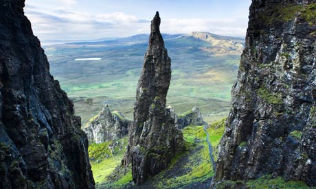
The Quiraing
Distance 4¼ miles
Start At high point on Staffin to Uig road, grid ref: NG440679
Further information and maps
The weird and wonderful rock formations of the Quiraing make it rightly popular with geologists, photographers and walkers – but the convoluted nature of the landscape means it never feels crowded. This high-level circular route also allows you to peer down on people below from a clifftop. It's a strenuous walk, so reward yourself with a coffee and homebaking at Staffin's Columba Centre (columba1400.com/locations/staffin) – itself an interesting departure from the traditional architecture of the island – which also houses a pioneering leadership centre for disadvantaged young people.
Kylerhea Otter Haven
Distance 1½ miles
Start Kylerhea Otter Haven car park, grid ref: NG786211
Further information and maps
The Isle of Skye is a hot spot for otters and this easy walk to a comfortable hide is a great way to begin your search for this elusive but beautiful creature. Take binoculars and look out for the distinctive v-shaped wake behind their heads as they swim in the narrow strait of water between the mainland and Skye. If otters remain out of sight, you are pretty much guaranteed to see seals basking on rocks near the lighthouse. The flat, well-surfaced walk, dotted with picnic benches, is great for people of all ages.
Ben Tianavaig, Braes
Distance 4 miles
Start Camastianavaig, grid ref: NG508388
Further information and maps
If you don't have the time or inclination to tackle the bare rock and airy peaks of the Cuillin or Red Hills, this wee coastal peak provides a fantastic taste of the best walking Skye has to offer. Climbing over rough ground, the route follows the rim of a dramatic escarpment above the sea, with wonderful views down to the water, often specked with passing porpoises and dolphins. Don't be alarmed if you also spot the huge conning tower of a naval submarine; these deep waters are used as a testing area for nuclear subs. The summit trig point provides the perfect backrest to eat your sandwiches while taking in the view over Portree Bay – the fishing boats and yachts bobbing in the harbour look like models from this height.
Coire Lagan
Distance 5½ miles
Start Glenbrittle, grid ref: NG408206
Further information and maps
Coire Lagan is the perfect introduction to the Cuillin – Skye's alpine-like mountain range of jagged peaks. This route climbs to a high ice-carved bowl on the side of the mountain which is the starting point for many of the climbs to the peaks on the ridge as well as being a superb destination in itself. If it fires your desire to conquer the Cuillin Munros, there are many excellent local mountain guides who will ensure you get the best out of each day, whether your ambition is simply to reach an airy summit or conquer the nemesis of many Munro-baggers, the infamous Inaccessible Pinnacle.
Oronsay Island, Ullinish
Distance 4 miles
Start Ullinish, grid ref: NG323374
Further information and maps
It's difficult to resist the lure of a tidal island, and as long as you pick your times to coincide with the receding tide there is plenty of time to cross the pebbly causeway and explore the high cliffs and stunning coastal views of Oronsay (the name means tidal island in Norse, a reminder of the centuries-long dominance of the Viking rulers in this part of the world). It juts out into Loch Bracadale to provide a wonderful high viewpoint over this sheltered, island-dotted sea loch, which is popular with seals and other wildlife, as well as sea-kayakers.
Talisker Bay
Distance 2 miles
Start Talisker, grid ref: NG326306
Further information and maps
To malt whisky buffs the name Talisker conjures a picture of peaty drams and long fireside evenings. Whether you visit the eponymous distillery before or after the walk is up to you but Talisker Bay is one of the few sandy beaches on Skye and perfect for a bracing dip, after which a warming dram would be very welcome. The short stroll passes Talisker House, visited in 1773 by Johnson and Boswell. Johnson no doubt also sampled the local whisky – he described the place much more favourably than most others they stayed at during their Hebridean tour.
Bla Bheinn
Distance 5 miles
Start Car park off B8083 road near Loch Slapin, grid ref: NG560215
Further information and maps
Bla Bheinn (or Blaven to give it its Anglicised name) is the one isolated peak of the black Cuillin. Its unique position means the climb to the summit is rewarded with an amazing view of the stark, jagged summits of the main ridge, one of the most awe-inspiring mountain vistas. Strike it lucky and you will climb up through cloud to emerge in a sunny inversion where the peaks rise from a cotton wool sea, and Brocken spectres provide rainbow halos reflected on the clouds. The walk is strenuous, involves a little scrambling and careful navigation but is within the capabilities of experienced and well-equipped hillwalkers.
Sgurr na Stri
Distance 15 miles
Start Sligachan, grid ref: NG487298
Further information and maps
This long but fairly easy going route sets off down Glen Sligachan which divides the Red and Black Cuillin peaks and provides awesome views as well as a good chance of spotting red deer. A good path makes it easy going until a large cairn indicates the start of the climb to the summit of Sgurr na Stri. From here the view is breathtaking; looking down on Loch Coruisk and tiny sandy beaches below all ringed by the looming jagged peaks of the Cuillin. Drink it all in before returning along the Glen to the famous climber's bar of the Sligachan Hotel (sligachan.co.uk) where an impressive whisky selection and micro-brewery will slake most thirsts.
The Cleared Coast of Boreraig and Suisnish
Distance 10¼ miles
Start Ruined church of Cill Chriosd on Broadford to Elgol road, grid ref: NG616207
Further information and maps
"A strange wailing sound reached my ears, I could see a long and motley procession winding along the road that led north from Suisnish. There were old men and women, too feeble to walk, who were placed in carts; the younger members of the community on foot were carrying their bundles of clothes … while the children, with looks of alarm, walked alongside … A cry of grief went up to heaven, the long plaintive wail, like a funeral coronach, was resumed … the sound re-echoed through the wide valley of Strath in one prolonged note of desolation". This was Archibald Geikie's eyewitness account of the 1853 forced clearance of the coastal villages on this route. Now deserted and eerily peaceful, it is possible to sit among the ruins and imagine a thriving community living against the stunning mountain backdrop. The sheep the crofters left to make room for still graze the hillsides, and you might spot an otter or eagle overhead, but the area remains largely deserted of human influence.
The Skye Trail
Distance 79½ miles
Start Rubha Hunish, grid ref: NG422742
Further information and maps
This seven-day, unofficial, long-distance hike is gaining popularity among those wanting to challenge themselves against the spectacular mountain and coastal scenery – and unforgiving weather – of Skye. Starting from the northernmost point of the island, it follows a varied course along high sea-cliffs and mountain ridges, taking in low lying crofts, villages deserted many years ago by the Highland Clearances, and modern day settlements, and gives a real taste of the island, its landscape, culture and heritage. Requiring a fair bit of planning and hillwalking experience, the Skye Trail is a fantastic backpacking adventure.
• Find more walking routes on the Isle of Skye on walkhighlands.co.uk
