Dun Totaig
Distance 4 miles
Start Letterfearn, Grid Ref: NG884238
Further information and maps
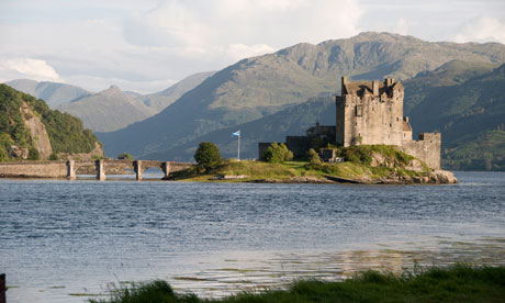
Eilean Donan castle (eileandonancastle.com)is one of the Highlands', indeed Scotland's, most iconic landmarks – a picture-perfect stone fortress surrounded by water (and often thronging with visitors). This walk, to a much older fortification, takes you along the opposite side of Loch Duich with spectacular views over the water to Eilean Donan and the peaks of Five Sisters of Kintail. The route follows an undulating minor road along the lochside until this narrows to a small track and then a winding path which emerges through the woods to reach Dun Totaig. This bronze age broch (drystone tower) occupies a natural vantage point guarding the entrance to Loch Duich.
Sandaig
Distance 2½ miles
Start Upper Sandaig on the Glenelg to Arnisdale road, grid ref: NG784152
Further information and maps
Immortalised by Gavin Maxwell in his book, Ring of Bright Water, Sandaig (or Camusfearna as Maxwell named it) still captures visitors' hearts today. An easy track leads down through the forest to emerge at the shoreline where a sandy arc looks out to the offshore islands. Sit quietly and you may well spot one of the otters that still frequent the area. The more energetic can pit their luck against the shoogly rope bridge that spans a small river running down from the waterfall behind the area where Maxwell's house once stood – an atmospheric memorial now marks this unspoilt and overgrown spot. This is a place to linger, soak up the views, wildlife and silence, and revel in the lack of mobile reception and other signs of modern day life. Afterwards have a celebratory dram at Maxwell's erstwhile local, the Glenelg Inn (glenelg-inn.com).
Plockton Crags
Distance 5½ miles
Start Near Loch Lundie on the Duirinish to Duncraig road, grid ref: NG808323
Further information and maps
Plockton is the perfect Highland village – a picturesque sheltered mooring complete with tidal island, palm trees, white-washed cottages, a couple of decent pubs and a smattering of arts and crafts shops. Lovely as it is, on a sunny summer's day Plockton can start to feel crowded and there's nothing like this hike to the summit of the crags which loom over the village to blow the cobwebs from your hair, taking in the view of the village and its stunning coastal setting. Although the walk involves a fair bit of ascent it is all on easy-to-follow tracks and minor roads; there is the option to extend it by starting from the village itself. A waterfront pint at the Plockton Inn (plocktoninn.co.uk) while watching the yachties disembark is the perfect reward for the exertions of the climb.
Plockton coral beach
Distance 1¼ miles
Start Plockton, grid ref: NG789329
Further information and maps
There is something truly magical about emerging through a thicket of trees and gorse onto a hidden white sandy beach strewn with seaweed and rockpools. Examine the sand more closely and you'll find it is made up of tiny coral-like pieces, actually a dried, calcified seaweed known as maerl. This is a place for exploring the rocks and tiny coves where wading birds and any number of tiny sea creatures can be seen. Binoculars will help you pick out the seals on nearby rocks but if you fancy a closer look Calum's Seal Trips (calums-sealtrips.com, adults £10, children £6) run twice a day during the summer season and offer a money-back guarantee if there are no seals.
Beinn Fhada
Distance 10½ miles
Start Morvich, Grid Ref: NG961211
Further information and maps
This part of the Highlands is crowded with Munros (peaks higher than 3,000 feet), and at first glance Beinn Fhada (or Ben Attow to give its Anglicised name) may not seem the most exciting option. This is a mountain which reveals itself slowly, initially hiding its dramatic northern corries. The initial ascent is eased by following the route of an old deer stalkers' path built to aid access to the best hunting spots. This high level route provides a serious mountain climb for those with the necessary experience, equipment and navigation skills.
Five Sisters of Kintail
Distance 9¼ miles
Start Layby on A87 Grid Ref: NH007136
Further information and maps
This is one of Scotland's classic ridge walks, taking in three Munros and climbing a total of nearly 4,600 feet. The distance of 9¼ miles means little in such steep and unforgiving terrain – for those used to long mountain days this makes for a superb, long hill walk with unrivalled views in good weather conditions. It's a fantastic feeling to look back on the celebrated outline of the Fife Sisters with the knowledge that you have traversed the ridge. The Kintail Lodge Hotel (kintaillodgehotel.co.uk) lies conveniently close to the end of the walk and provides well-deserved, hearty meals.
The Old Coast Path, Corran
Distance 5 miles
Start Corran Grid Ref: NG849094
Further information and maps
At the height of the 19th-century Scottish herring boom, the waters of fjord-like Loch Hourn were heaving with boats bringing their catch ashore. This path was built to link the tiny fishing settlements along the edge of the loch and allow the precious cargo of "silver darlings" to be carried ashore. Now fallen into neglect, the well-constructed path can still be traced as it edges its way along the steep sides of the loch, crossing seemingly impassable rock faces with relative ease and an unforgettable prospect of the rough peaks of the Knoydart peninsula across the water. Revive yourself after this adventure with a strupag (Gaelic for cuppa) at Sheena's Tea Hut. Customers used to have to share their home baking with a friendly stag named Bin Laden, but like his namesake he has departed for pastures new.
Beinn Sgritheall
Distance 6¼ miles
Start Arnisdale Grid Ref: NG843105
Further information and maps
Not one for the faint hearted, this Munro rises mercilessly from sea level to a height of 974m (3,196 ft). This direct route – a turf-clutching crawl at times – has ample rewards, as not only is the summit reached relatively quickly, but the great void all around makes for a fantastic viewpoint. The 360-degree panorama takes in the remote and wild mountains of the Knoydart peninsula, Skye, and the peaks of Kintail to the north. Once safely back down at sea level, if time allows visit the Ceilidh House and Heritage Centre which houses an interesting display on local history, boasts loos with possibly the best view in the Highlands and regularly hosts gigs and ceilidhs where visitors are most welcome.
The Glenelg Brochs to Suardalan
Distance 8¾ miles
Start Dun Telve Broch near Glenelg Grid Ref: NG829174
Further information and maps
Nothing can quite prepare you for the power of these immense and ancient structures. Built as huge fortified retreats during the iron age, enough remains of these high, double-walled tapering towers to allow your imagination to rebuild the ruined sections. Whole settlements, complete with livestock could have retreated to these brochs at times of Norse attacks from the sea. After exploring the brochs this walk wanders further up the glen, eventually reaching a more modest structure, Suardalan bothy, now used as a walker's shelter and a welcome rest spot on open and exposed terrain.
Ardintoul Circuit
Distance 8 miles
Start Glenelg Ferry Grid Ref: NG795214
Further information and maps
Last time we did this route we had a close encounter with both an otter and a sea eagle. While we sat on the shore eating our lunch we watched the otter tucking into a butterfish with the same enthusiasm – and completely oblivious to our presence. The sea eagle didn't hang around for quite so long but the sheer bulk of this massive raptor showed why they are often dubbed "flying barn doors". This lovely coastal route also gives you an excuse to hop on the Skye ferry, which plies its way over the narrows to Kylerhea from the start of this walk. Now managed by enthusiastic locals, up to six cars can be squeezed onto the Glenachulish, the only hand-operated turntable ferry in operation in the UK.
• Find more walking routes Lochalsh at walkhighlands.co.uk
