Distance 30 miles (48.5km)
Classification Challenging
Duration 12 hours over two days
Begins Brecon
Ends Abergavenny
OS grid refs SO045285, SO295145
Walk in a nutshell
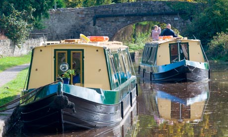
This really is a walk of contrasts: the first day a spectacular tour of the mountains of the Brecon Beacons, the second a pleasant waterside ramble. Day one begins in the historic town of Brecon and heads across to the Brecon Beacons. At Cwm Gwdi you begin a rapid ascent to Pen y Fan, one of three major peaks in the Brecon horseshoe, dipping into the dramatic saddles between Cribyn and Fan y Big. Then it's a gentle descent into Talybont-on-Usk via a wooded walk beside a reservoir. The second day covers a longer distance, but it's flat and serene, tracing the route of the 200‑year-old Monmouthshire and Brecon canal from Talybont to Abergavenny.
Why it's special
Pen y Fan is the highest mountain in southern Britain, and the Brecon horseshoe is a must for serious walkers. The views are thrilling. Look out for red kites (pictured) in the mountaintops. The second day's historic landmarks are also a draw, with Llangattock lime kilns and the 343m Ashford tunnel among the highlights.
Keep your eyes peeled for
There are four second world war plane crash sites up on the horseshoe. Some of the wreckage is still there (bit.ly/I6YbVM). And at the end of the first day, along the wooded section of the walk, look out for remnants of an old Victorian tram road and a garden dedicated to the Vaughans, a Victorian family of herbalists, poets and alchemists who lived locally.
Stay overnight at
Try the plush Malt House (malthousetalybont.co.uk), a B&B with a self-catering cottage and a swimming pool, which is just a stone's throw from the local pub, the White Hart Inn (breconbunkhouse.co.uk).
Recover afterwards
In Aber you can't miss the Hen and Chickens on Flannel Street (sabrain.com/henandchickens), a Brains pub which pulls great pints as well as serving cracking food, including an all-day breakfast: perfect sustenance for weary walkers.
If it's tipping down
It has to be the Big Pit: National Coal Museum, Blaenafon (museumwales.ac.uk/en/bigpit). Head down the mines for a fascinating guided tour led by miners who worked the pits when they were in operation. Not for the faint‑hearted!
How to get there
The X43 bus service runs between Aber and Brecon, and Abergavenny train station can be reached via Cardiff and Newport, Manchester and further afield. See Traveline Cymru (traveline-cymru.info) for details.
Step by step
Day one
1 Follow the road west out of Brecon over the river Usk on Ship Street, which turns successively into Bridge Street, Orchard Street, then Church Street, before becoming Newgate Street. Then turn left on to Ffrwdgrech Road.
2 Continue under the A40 until you are in open country. Eventually you will come to a three-pronged fork in the road. Take the left fork. Follow the road, ignoring a left and then a right, until you come to a cattle grid with the Cwm Gwdi National Trust sign. Continue up past the car park and on to the hill.
3 Once over the second stile, follow the path up Cefn Cwm-Llwch to Pen y Fan, which stands at 886m high.
4 Looking at the Pen y Fan sign, turn right and head down the ridge, then up to Cribyn. Take the ridge down to the metalled track.
5 Head up, taking the contour path of Fan y Big. Just after the large stone on your left (SO041197), halfway around the ridge, take the small track half-right across the moor. This leads to a small cairn and a larger collection of stones and shards of rock (SO047189). The path keeps ahead and then bears to the left, joining with a clear track by the waterfalls at Blaen Caerfanell.
6 Follow this path along the edge of the ridge and down to the car park in Talybont-on-Usk.
Day two
1 From Talybont-on-Usk, follow the canal towpath south-east, walking overground at the Ashford tunnel and passing the five locks en route to Llangynidr.
2 Follow the towpath/Usk Valley walk towards Dardy, staying by the canal.
3 Pass to the south of Llangattock to reach Gilwern. Along this stretch, the Sugar Loaf mountain comes into view.
4 At Gilwern, cross the road to pick up the canal path east once more, there's no need to leave the path since it winds through the gyratory systems and a complex of A-roads east of Gilwern.
5 Continue east as the path winds around Govilon. Pass the white house down to your left to reach the boat houses (SO285130).
6 Follow the path north and downhill. Cross the Llanfoist old railway crossing and continue ahead, signposted for a garden centre. Go through a metal gate and follow the footpath under the A465. Bear right to reach (and cross) Usk bridge and bear half-right across Castle Meadows, to reach Abergavenny town centre.

