Distance 21 miles (33.8 km)
Classification Challenging
Duration 10 hours over two days
Begins Junction of Downs Link and South Downs Way
Ends Southease railway station
OS grid refs TQ197096, TQ432055
Walk in a nutshell
This two-day walk (9 miles on day one, 12 miles on day two) along the South Downs national trail captures the essence of Britain's newest national park. Starting near Steyning, the path moseys eastwards along the top of the South Downs, high above Brighton and a succession of quintessentially English villages and the occasional pub. It finishes in the hamlet of Southease with its conveniently situated railway station.
Why it's special
Anyone who can look upon the curves of the South Downs and not want to rush up them trilling "the hills are alive ..." needs to have their pulse checked. This section of the South Downs Way affords wonderful views and plenty of chalky hills topped with grassy paths.
Keep your eyes peeled for
The truly impressive Devil's Dyke, the largest dry valley in the UK. The Victorians loved it so much they put a fairground and a cable car here. Thankfully, today it's back to its wonderful pristine self. At 248m, the iron age stronghold of Ditchling Beacon (now a nature reserve) is one of the highest points on the South Downs and possessor of eye-smacking 360-degree views.
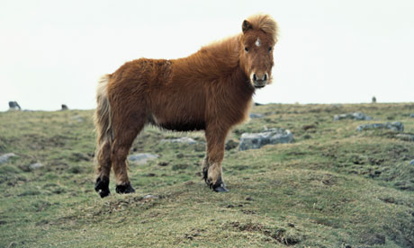
Exmoor ponies (pictured) can be seen grazing above Cold Coombes, while in summer the Downs pulsate with flying wildlife – look out for whitethroats and yellowhammers, and copious butterflies, including the chalkhill blue and brown argus.
Stay overnight
At the White Barn in Ditchling , where you can nab their one and only bedroom.
Recover afterwards
At the Abergavenny Arms , an oak-beamed village boozer with a fine selection of Sussex ales in Rodmell.
If it's tipping down
Pop into the charming Marlipins Museum and marvel at how Shoreham-by-Sea came to be the centre of the British silent film industry.
How to get there
Take the train to Shoreham-by-Sea; the railway station is the alternative starting point of the walk. If you'd rather take the bus to the normal starting point, just south of Upper Beeding, hop on the 2A.
Step by step
Day one
1 Starting near the quarries at the junction of the Downs Link and South Downs Way (near Steyning), follow the route east from the A283 via Edburton Hill towards Devil's Dyke. (For an optional, longer route, start at Shoreham-by-Sea railway station and walk up the Downs Link to the junction with the South Downs Way.)
2 The South Downs Way sweeps you behind the viewing platform at Devil's Dyke, so you need to make a brief diversion here, picking up the path behind woodland by Devil's Dyke Road.
3 Continue along the South Downs Way to the next valley where you'll find Saddlescombe Farm and its cafe.
4 If you're staying in Ditchling, leave the ridge of the downland by any of the tracks down the steep hill. Take care along the side of Ditchling Road as you walk into the village.
Day two
1 From Ditchling, it's preferable to avoid the traffic by taking the public footpath just east of the post office that sweeps diagonally south-east towards the Nye, then south past Jointer Copse, crossing Underhill Lane to climb steadily up to the ridge just east of Ditchling Beacon.
2 The South Downs Way is clearly marked from here, heading east before turning south and zigzagging down to Housedean Farm.
3 Continue to follow the South Downs Way as it sweeps around Swanborough Hill, before picking up the military road to Southease.

